Severe Storms Loom
Stronger Storms, Damaging Winds, and Flooding Expected Across DC and Baltimore Region This Week
Anonymous
Key Points
1
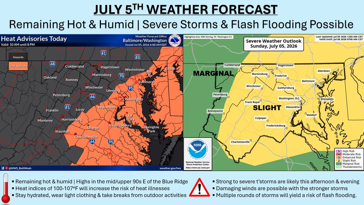
In Washington, DC, Sunday morning will be muggy with patchy fog in low-lying spots and temperatures around 70°F, followed by highs near 86°F and a 25–30% chance of scattered showers or thunderstorms late in the day. Heavier downpours could briefly pond water on urban streets.
2
On Tuesday, forecasters expect a two‑stage setup—first a warm front in the morning, then a potent cold front in the afternoon—raising the risk for organized, strong to severe thunderstorms with damaging winds and heavy rain.
3
Annapolis and other harbor areas could experience minor coastal flooding early Tuesday due to a high astronomical tide combined with onshore winds pushing water levels higher in typically flood-prone spots.
4
Across Maryland, Tuesday is forecast for widespread rain and thunderstorms, with storms arriving Sunday evening and more isolated activity Monday before a drier pattern develops later in the week.
Baltimore and Washington, D.C. face a stormy stretch this weekend and into next week, with the biggest threat arriving Tuesday. Forecasters warn that a strong cold front could bring organized, severe thunderstorms capable of damaging winds and heavy downpours across the region.
Before Tuesday's main event, residents should expect hot and humid conditions through the weekend. Highs will reach the mid-to-upper 80s, with scattered afternoon storms possible as early as Sunday. The National Weather Service urges residents to monitor forecasts closely and be ready to move plans indoors.
Sunday Brings Heat, Humidity, and Late Storm Chances
Sunday morning in Washington, D.C. will start muggy. Patchy fog could settle into low-lying areas, with temperatures around 70°F at dawn. By afternoon, highs climb to near 86°F. There is a 25–30% chance of scattered showers or thunderstorms late in the day.
Any heavier downpours could briefly pond water on urban streets. Residents should watch for localized street flooding, especially in areas that drain slowly. The overall storm risk Sunday remains relatively low, but conditions will feel uncomfortable throughout the day due to high humidity.
Tuesday's Two-Stage Storm System Poses Biggest Risk
Tuesday is shaping up to be the most dangerous weather day of the week. Forecasters expect a two-stage setup. First, a warm front moves through in the morning. Then a potent cold front sweeps in during the afternoon. Together, they raise the risk for organized, strong to severe thunderstorms.
The main threats Tuesday include damaging winds and heavy rain. Across Maryland, widespread rain and thunderstorms are forecast for much of the day. Storms will begin arriving Sunday evening, with more isolated activity expected Monday before the bigger system hits Tuesday.
Annapolis Harbor Areas Face Minor Coastal Flooding Risk
Coastal communities around Annapolis and other harbor areas face an added threat early Tuesday. A high astronomical tide — meaning the tide is naturally at its peak due to the moon's position — will combine with onshore winds. That combination could push water levels higher in flood-prone spots.
Minor coastal flooding is possible in typically vulnerable areas around the harbor Monday into Tuesday. Residents near the water should keep a close eye on tide forecasts. Areas that already flood during heavy rain events will be at the greatest risk.
Drier, Cooler Air Arrives by Mid-Week for Relief
The rough stretch does not last all week. After Tuesday's cold front pushes through, drier air is expected to move into the region by mid-to-late week. Daytime highs should drop, and the oppressive humidity that defines the weekend will ease considerably.
That pattern shift will bring welcome relief after several days of heat and storm chances. For now, residents across the Baltimore and D.C. region are advised to stay weather-aware, have a backup plan for outdoor activities, and check local forecasts frequently as the week progresses.
Sentiment
Mostly NegativeNEGATIVENEUTRALPOSITIVE
Publishers
11
Articles
8
Reach
19
Topics
A
AnonymousAuthor


