Multi-State Tornado Warnings
Severe Tornado Warnings Expand Across Multiple States With Immediate Shelter Advisories Issued
Anonymous
Key Points
1
Oregon: A tornado warning for Columbia County near Deer Island remained in effect with radar-indicated rotation and the storm moving north at about 20 mph; pea-sized hail was possible.
2
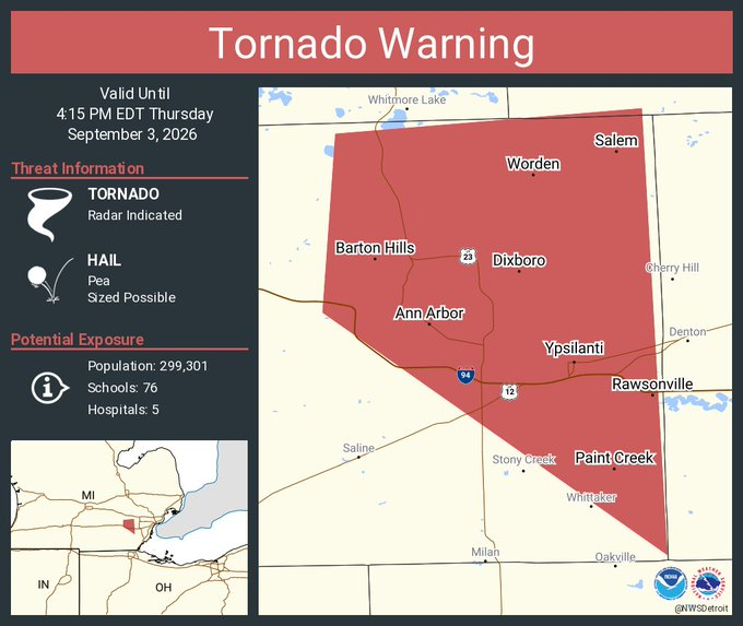
Livingston County, Michigan: A tornado warning was issued until 3:45 p.m. near Fowlerville, with radar-indicated rotation and the storm moving southeast at 40 mph; flying debris was expected and damage to mobile homes, roofs, trees, windows and vehicles was possible. Predicted arrival times included Howell/Fowlerville around 3:10 p.m., Brighton/Pinckney around 3:25 p.m., and Hamburg/Whitmore Lake around 3:30 p.m.
3
Grand Rapids area, Michigan: A tornado warning was in effect from 1:47 p.m. to 2:15 p.m. and covered Gratiot and Saginaw counties; the storm was near St. Charles moving southeast at about 40 mph, with hail up to 0.75 inches and potential for torrential rainfall and flash flooding; additional severe thunderstorm warnings were in effect for Isabella, Gratiot, Saginaw and Midland counties.
Tornado warnings blanketed multiple states Thursday as severe storms with rotating clouds moved across the country. National Weather Service alerts stretched from Oregon to Michigan to Texas, with officials warning of flying debris, large hail, and potential structural damage. Residents in affected areas were told to seek shelter immediately in basements or interior rooms away from windows.
Oregon Storm Moving North Near Deer Island
A tornado warning remained in effect for Columbia County, Oregon, near Deer Island on Thursday. National Weather Service Portland said radar showed rotation in the storm as it moved north at about 20 mph. The agency warned of pea-sized hail and urged residents to take cover in sturdy shelter.
The warning highlighted the dangers of rotation that can spawn tornadoes. Residents in the area were advised to move away from windows and avoid mobile structures that offer little protection during severe weather.
Michigan Warnings Track Southeast at 40 MPH
In Michigan's Livingston County, a tornado warning issued near Fowlerville was set to expire at 3:45 p.m. Thursday. ClickOnDetroit reported the storm was moving southeast at 40 mph with radar-indicated rotation. Flying debris posed a serious threat, and damage to mobile homes, roofs, trees, windows and vehicles was possible.
The National Weather Service predicted specific arrival times: Howell and Fowlerville around 3:10 p.m., Brighton and Pinckney around 3:25 p.m., and Hamburg and Whitmore Lake around 3:30 p.m. A separate warning covered the Grand Rapids area, where hail reached up to 0.75 inches and flash flooding threatened parts of Gratiot and Saginaw counties.
Flooding Risk Spreads Across Northeast
Beyond tornado threats, flood warnings remained in effect across parts of the Northeast, including northern Delaware and southern New Jersey. Rising rivers posed dangers to drivers and homes in low-lying areas. National Weather Service officials urged motorists to avoid flooded roads, repeating the safety message: turn around, don't drown.
The multiple warnings reflected how a single weather system could spawn different hazards across wide areas. Residents faced a combination of tornado risks, hail, heavy rain, and flooding within hours as storms tracked through different regions at varying speeds.
How Tornado Warnings Get Issued and What to Do
Tornado warnings are issued when National Weather Service radar detects rotation in a storm, or when a tornado is actually spotted. Sometimes spotters on the ground confirm what radar shows. Unlike watches, which mean conditions are favorable, warnings mean danger is imminent and action is needed right now.
The safest action is to move to a basement or the lowest interior room in a building, away from windows. People in mobile homes should leave immediately and get to a sturdy building or designated shelter. The few minutes it takes to reach safety can mean the difference between life and death when a tornado strikes.
Sentiment
Mostly NegativeNEGATIVENEUTRALPOSITIVE
Publishers
18
Articles
14
Reach
32
Topics
A
AnonymousAuthor


