Kern County Earthquake
Revised 4.1 Magnitude Quake Strikes Kern County, Felt Widely Across Southern California
Anonymous
Key Points
1
The initial 4.3-magnitude quake was later downgraded to 4.1, reflecting a revision in the USGS assessment.
2
USGS’ Did You Feel It map highlighted specific locales that felt the tremor, including Moorpark, Santa Clarita, Crestline and San Bernardino, illustrating how widely the shaking was reported within Southern California.
3
Two quakes occurred in quick succession near Johannesburg: a larger event around 9:40 a.m. (initially reported as magnitude 4.3; depth about 4–4.7 miles) followed by a smaller 2.2-magnitude tremor at 10:01 a.m., about 11 miles WSW of Johannesburg at a depth near 5 miles.
4
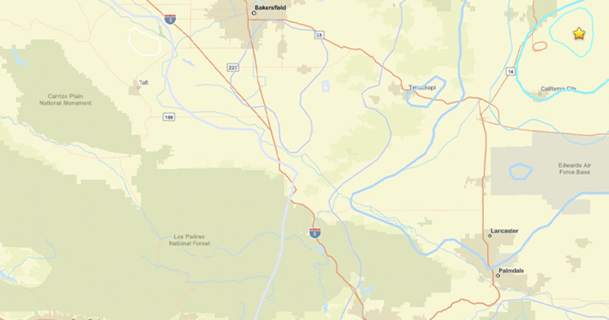
Geographically, the Johannesburg area is described as being north of Edwards Air Force Base, placing the events in a region familiar to Kern County’s western desert corridor.
A 4.3-magnitude earthquake struck near Johannesburg in Kern County on Monday morning, shaking a wide stretch of Southern California. The quake hit around 9:40 a.m., centered about 11 miles west-southwest of Johannesburg at a shallow depth of roughly 4 to 5 miles, according to USGS.
No injuries or major damage have been reported. The shaking was felt across multiple counties, including Ventura, Los Angeles, San Bernardino, and parts of the Inland Empire. A second, smaller tremor followed about 20 minutes later.
Two Quakes Strike in Quick Succession Monday
The sequence began at 9:40 a.m. with the larger 4.3-magnitude event. Then, at 10:01 a.m., a 2.2-magnitude aftershock struck the same area — about 11 miles west-southwest of Johannesburg at a depth near 5 miles. A third tremor, a preliminary 2.4-magnitude quake, was detected at 11:29 a.m. in the same vicinity, according to Sacramento Bee.
The Johannesburg area sits north of Edwards Air Force Base in Kern County's western desert corridor. The region is sparsely populated, which likely helped limit the impact of the shaking. All three events occurred at shallow depths, which can make tremors feel stronger at the surface.
Initial 4.3 Magnitude Revised Down to 4.1
Early reports pegged the main quake at 4.3 magnitude. USGS later revised that figure down to 4.1. Initial readings are always provisional. As more seismic data comes in, scientists adjust their estimates to be more accurate. The revision was small but reflects how quickly information changes right after a quake.
Quakes in the 2.5 to 5.4 range are typically felt by people nearby but rarely cause major structural damage. Shallow depth and loose soil can amplify shaking. In this case, the remote location kept the risk low, though residents across a broad area still noticed the tremors.
Shaking Felt From Moorpark to San Bernardino
USGS's "Did You Feel It" map showed reports pouring in from across Southern California. Residents in Moorpark, Santa Clarita, Crestline, and San Bernardino all logged felt reports. That spread — covering communities more than 100 miles apart — shows how far even a moderate quake can travel through the region's geology.
Officials encourage anyone who felt the shaking to submit a report through the USGS "Did You Feel It" tool. The crowdsourced data helps seismologists map shaking intensity across a wider area than sensors alone can capture. Reports from Fresno Bee and Modesto Bee confirmed the tremor was widely noticed across Central and Southern California.
What to Do Before the Next Aftershock Hits
Seismologists warn that aftershocks can follow for days, weeks, or even months after a main quake. They typically get smaller over time, but not always. Monday's sequence is a reminder that any quake can be followed by more activity. USGS and safety experts urge residents to stay prepared.
The standard guidance holds: drop to your hands and knees, take cover under a sturdy table or desk, and hold on until shaking stops. If you are outdoors, move away from buildings and power lines. If you are in a car, pull over safely and stay inside. San Luis Obispo Tribune and Merced Sun-Star both reminded readers of these steps following Monday's events.
Sentiment
Mostly NegativeNEGATIVENEUTRALPOSITIVE
Publishers
11
Articles
20
Reach
31
Topics
A
AnonymousAuthor


