Overnight storm and flood risks
Severe storms bring damaging winds and flood risks to Southeast Wisconsin overnight
Anonymous
Key Points
1
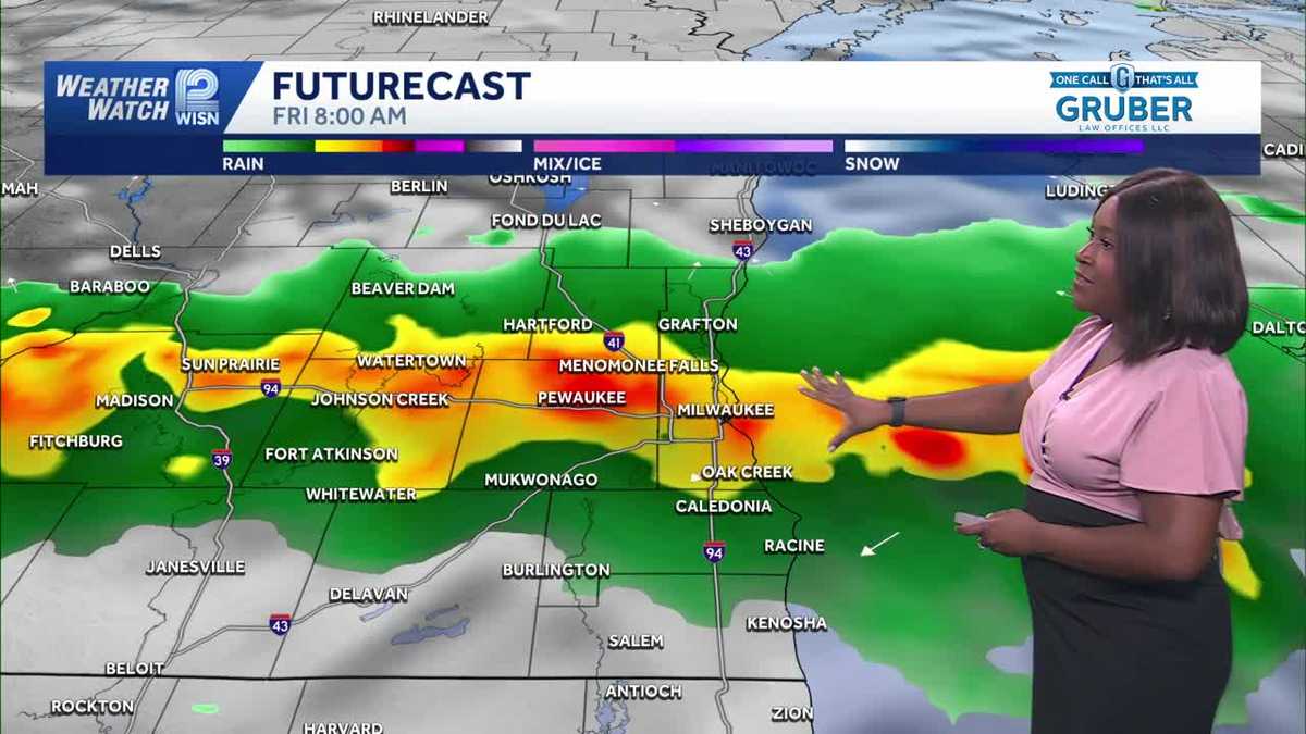
The late-night/early-Friday storm round is tied to a stationary front draped over southeast Wisconsin, with storms returning from late tonight into the early morning hours of Friday.
2
Storm Prediction Center guidance highlighted much of the area under a “slight risk” for severe weather, rated 2/5, with damaging winds and flooding as the main threats.
3
Forecasters warned the overnight window of highest concern runs roughly from 8 p.m. to 5 a.m. Friday, when thunderstorms could produce large hail, strong winds, and localized flooding.
4
Earlier strong storms caused power impacts and damage: We Energies reported more than 21,000 customers without power, and Washington County saw widespread tree damage across Richfield, including uprooted trees.
Southeast Wisconsin faces a dangerous overnight storm threat Thursday into Friday, with damaging winds, large hail, and heavy rain expected to pummel the region. WISN warned that repeated downpours could trigger localized flooding and ponding, particularly across northern Milwaukee County and northeast Waukesha County where 1 to 2 inches of rain had already fallen by Thursday afternoon.
The Storm Prediction Center rated much of the area under a "slight risk" for severe weather—level 2 out of 5—with the most dangerous window running from 8 p.m. Thursday through 5 a.m. Friday. WDTV reported that earlier storms had already caused widespread damage: We Energies lost power to more than 21,000 customers, and Washington County saw uprooted trees across Richfield and surrounding areas.
The Overnight Window Most Likely to Turn Severe
Thunderstorms will return to the forecast late Thursday evening as a stationary front stalls over southeast Wisconsin. WDTV flagged the 8 p.m. to 5 a.m. window as the period of highest concern, when storms could produce damaging wind gusts, large hail, and torrential rainfall that leads to flash flooding in localized areas.
Hot, humid air will fuel these storms, keeping instability high overnight. Forecasters warned that if the heaviest rain stays concentrated over the same areas already soaked by earlier storms, WISN noted that ponding and localized flooding becomes a real threat to roads and low-lying neighborhoods.
Damaging Winds and Power Outages Already Spreading
Strong storms Thursday afternoon and evening have already left thousands in the dark. We Energies confirmed that more than 21,000 customers lost power, with widespread tree damage reported across Washington County—including snapped branches and completely uprooted trees in Richfield.
Overnight storms could worsen the damage. WDTV emphasized that damaging winds are the primary threat, capable of downing more trees and power lines, further extending outages into Friday morning. Heavy rain will compound the danger by making roads hazardous and swelling streams.
Relief Arrives Friday Afternoon Into the Weekend
Once storms clear Friday morning, conditions will dry out and improve rapidly. KSNBLOCAL4 indicated that Friday afternoon will bring more sun and clouds with highs in the upper 70s to low 80s—a dramatic shift from the oppressive heat and severe weather of Thursday night.
The holiday weekend is shaping up mostly dry. Labor Day is expected to remain dry with plenty of sun, though a small chance of showers exists near the holiday itself. Saturday carries a low storm chance, meaning residents should have time to clean up storm debris and restore power before conditions turn more unsettled again.
Sentiment
Mostly NegativeNEGATIVENEUTRALPOSITIVE
Publishers
16
Articles
1
Reach
17
Topics
A
AnonymousAuthor


