Strong El Niño Warming Fall
NOAA Forecasts Warm Fall Across Much of US as El Niño Strengthens
Anonymous
Key Points
1
In Saginaw, temperatures are forecast to reach about 68–70°F through the weekend, with overnight lows in the 40s and winds easing from gusts of up to 25 mph to 5–10 mph. Forecasters also see a potentially widespread round of rain on Sept. 30.
2
The Superior region is expected to follow a more unsettled pattern than the sunny conditions elsewhere: clouds return overnight Wednesday, scattered showers arrive Thursday, Friday remains dry but overcast, and the weekend brings additional shower chances.
3
In Barrie, Ontario, climatologist David Phillips said the first frost is not expected until October and predicted that fall foliage will begin changing after Thanksgiving but before Remembrance Day, potentially producing a particularly vivid October display.
4
Scientists measured a daily sea-surface temperature anomaly of 3.05°C in a key central-eastern Pacific region on Sept. 19, narrowly exceeding the previous 3.02°C record set during the 2015 El Niño; the event’s peak is still expected later this year.
5
The WHO said more than 150 million people are already experiencing acute food insecurity worldwide and warned that El Niño-related disruption could increase risks from malaria, dengue, chikungunya, yellow fever and Zika, in addition to cholera and malnutrition.
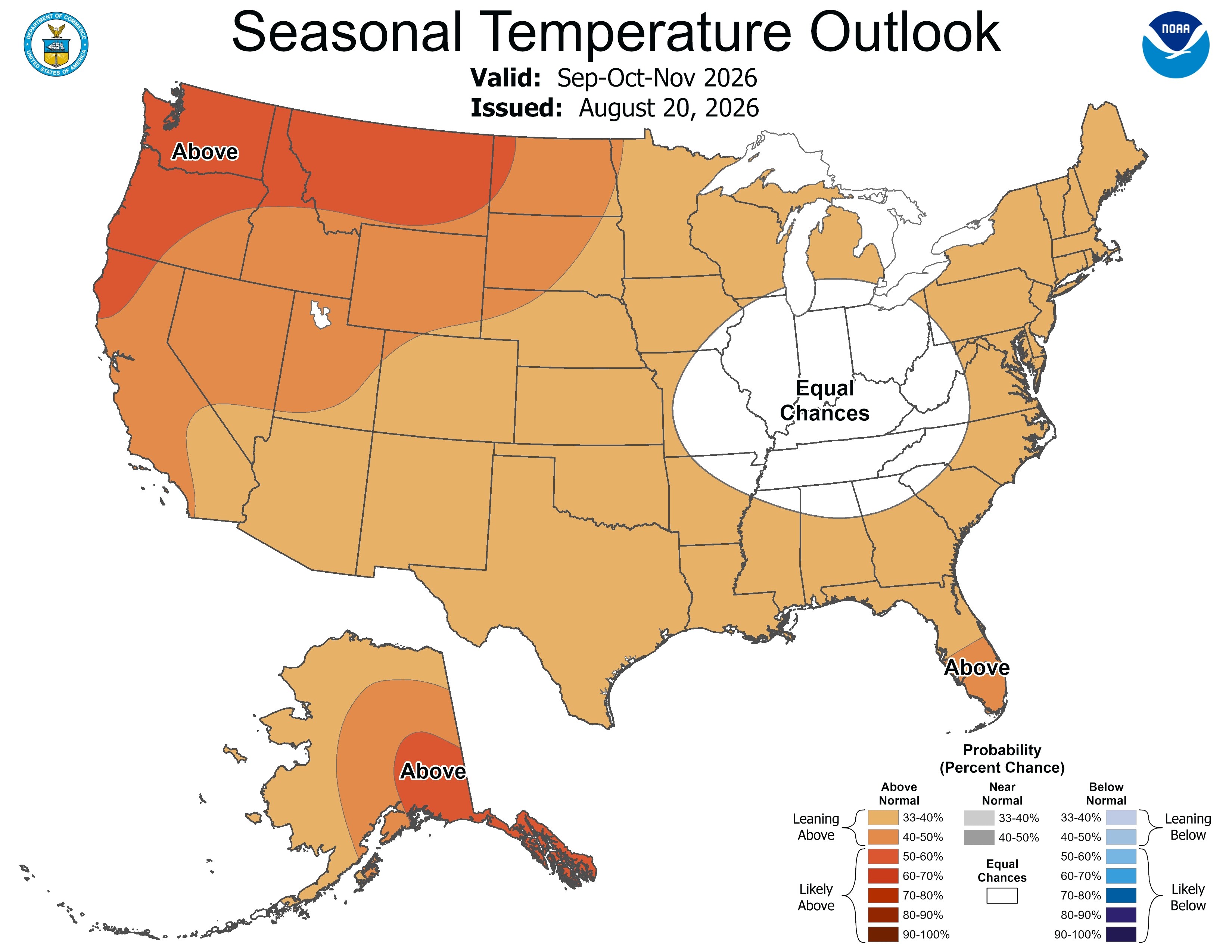
NOAA is forecasting a warmer-than-normal fall across most of the United States and Canada as El Niño strengthens to record intensity. Scientists measured a sea-surface temperature anomaly of 3.05°C in the central equatorial Pacific on September 19, NOAA reported, surpassing the previous record of 3.02°C set during the 2015 El Niño. The current event is expected to peak later this year and bring potential for warmer, drier conditions across the northern U.S. and wetter weather in parts of the South.
The unusually strong El Niño poses serious global health risks. The World Health Organization warned that more than 150 million people are already experiencing acute food insecurity worldwide, and the event could worsen heat, drought, flooding, malnutrition, cholera, and mosquito-borne diseases—especially in fragile communities. WHO officials called El Niño a "significant public health threat, not just a climate phenomenon."
Mild Fall Weather Spreads Across Great Lakes and Midwest
Early fall will bring generally mild conditions to much of North America. In Saginaw, Michigan, temperatures are forecast to reach 68–70°F through the weekend with overnight lows in the 40s, WNEM reported. Winds will ease from gusts of up to 25 mph to just 5–10 mph. A widespread round of rain is expected on September 30. WNEM noted that pleasant weather will continue throughout the week with highs in the upper 60s and lower 70s.
The Superior region will follow a more unsettled pattern than other areas. Superior Telegram reported another sunny day ahead, but clouds will return overnight Wednesday, followed by scattered showers Thursday. Friday will remain dry but overcast, and the weekend will bring additional shower chances. Duluth News Tribune also noted sunny conditions for the region.
October Expected to Break Warming Trend Across North America
NOAA forecasts warmer-than-normal conditions extending through October across most of the United States and Canada. No areas in the Lower 48 states are favored for below-normal temperatures through early spring. Cooler conditions are more likely only across Washington, parts of the Pacific Northwest, and the Mid-Atlantic from September 26–30, while southern Texas has a strong warm signal. The Midwest is expected to be drier than average.
In Barrie, Ontario, climatologist David Phillips predicted that the first frost will not arrive until October. Phillips said fall foliage will begin changing after Canadian Thanksgiving but before Remembrance Day, potentially producing a particularly vivid October display. This delayed frost means residents could save money on heating costs during the extended mild period.
Record El Niño Reaching Peak Intensity Later This Year
El Niño has shattered previous temperature records at an unprecedented pace. NOAA scientists measured the Niño 3.4 region reaching 3°C above average approximately two months earlier in the calendar year than during the historic 2015 event. Climate Prediction Center reports a greater than 90% chance of a "very strong" El Niño persisting through spring 2027 and a 75% probability of reaching record intensity between October and December.
The rapid ocean warming reflects subsurface heat anomalies exceeding 10°C that continue feeding warm water to the surface. World Meteorological Organization officials noted that Earth has just lived through the two hottest months on record. The event poses severe wildfire and drought risks for Southern Hemisphere nations as it peaks in late 2026.
Global Food Security and Disease Risks Intensify
El Niño-related disruptions threaten food systems already under strain. WHO warned that the event could increase risks from malaria, dengue, chikungunya, yellow fever, and Zika in addition to cholera and malnutrition. Officials identified malnutrition and cholera as "very high" risks in impacted zones with fragile health infrastructure. Fragile communities lack resources to prepare for or respond to the cascading health impacts.
The global humanitarian system faces compounded challenges as it confronts this crisis. Experts noted that the climate shock arrives at a moment when international aid capacity has been strained by recent budget cuts. PAHO and other regional health organizations are bracing for increased demand on already-stretched resources as El Niño peaks over the coming months.
Sentiment
Mostly NegativeNEGATIVENEUTRALPOSITIVE
Publishers
27
Articles
27
Reach
54
A
AnonymousAuthor


