Weekend Weather Forecast
Warming Northeast Weather Precedes Scattered Showers and a Cool Weekend
Anonymous
Key Points
1
In Maine, the approaching cold front is expected to cross the state Wednesday night with little moisture, making the passage largely unnoticed; it should then stall just offshore Thursday.
2
The pressure gradient behind the front could produce northwest wind gusts of 30–40 mph in parts of Maine on Friday, before colder air arrives Friday night and Saturday.
3
Forecasters are also monitoring the tropical Atlantic, noting that roughly two and a half months of hurricane season remain.
4
South Texas showers will be driven primarily by the westward-advancing afternoon sea breeze each day, and the moist atmosphere could make individual scattered showers or thunderstorms locally substantial.
5
Connecticut could see patchy fog and overnight lows in the 65–70-degree range as humidity increases ahead of Thursday’s shower chances.
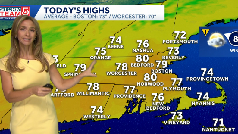
The Northeast will see warmer, more humid conditions Wednesday with temperatures climbing to the mid-70s and near 80 degrees WESH, mixed sun and clouds, and mostly isolated showers or sprinkles. Scattered showers and thundershowers become much more likely Thursday afternoon and evening as moisture and frontal systems push through, with the greatest chances hitting southern and coastal areas WCVB.
Thursday's Shower Activity and Regional Impacts
Thursday will bring Impact Weather to the Boston area and Massachusetts, with afternoon showers and temperatures staying above normal WCVB. In South Texas, scattered thunderstorms will be most likely along the immediate coast Houston Chronicle, driven by afternoon sea-breeze moisture. Individual storms could produce locally heavy downpours in some areas.
Connecticut could see patchy fog overnight with lows in the 65–70-degree range as humidity builds before Thursday's rain chances. Western portions of Maryland face stray shower chances, though isolated storms could reach other areas WMAR2News. Drier air has already moved in to some regions east, with forecasters predicting a change in weather patterns for the next few days WLOX.
Maine's Front and Friday Wind Gusts
The approaching cold front will cross Maine Wednesday night with little moisture, making the passage largely unnoticed. The system will then stall just offshore Thursday, keeping the state in transition. Friday brings the main impact: the pressure gradient behind the front could produce northwest wind gusts of 30–40 mph in parts of Maine before colder air arrives Friday night and Saturday.
Friday Dries Out; Weekend Turns Cooler
Brief showers may linger in some locations Friday morning, but conditions will turn noticeably drier, sunnier, and less humid throughout the day. Saturday will be mostly sunny with a fall-like feel and cooler temperatures across the Northeast. However, unsettled weather returns Sunday with another round of rain or showers expected, and conditions may stay unsettled into early next week.
South Texas Sea-Breeze Showers and Atlantic Monitoring
Gulf moisture will fuel afternoon sea-breeze showers across South Texas through Friday, with the moist atmosphere capable of producing locally substantial scattered showers and thunderstorms. Saturday will bring briefly drier air and a break in the action. Another chance for scattered showers is expected Sunday night. Forecasters are also monitoring the tropical Atlantic, noting that roughly two and a half months of hurricane season remain.
Sentiment
Mostly PositiveNEGATIVENEUTRALPOSITIVE
Publishers
55
Articles
12
Reach
67
A
AnonymousAuthor


