Record Southern Heatwave Persists
Persistent Heat Dome Prolongs Dangerous Late-Season Temperatures Across the American South
Anonymous
Key Points
1
Dallas recorded temperatures of at least 100 degrees on 22 of the last 23 days; its 49 triple-digit days this year are nearly double the 20-year average of 25. Austin has recorded 43 such days versus an average of 29, while El Paso has recorded 52 versus an average of 34.
2
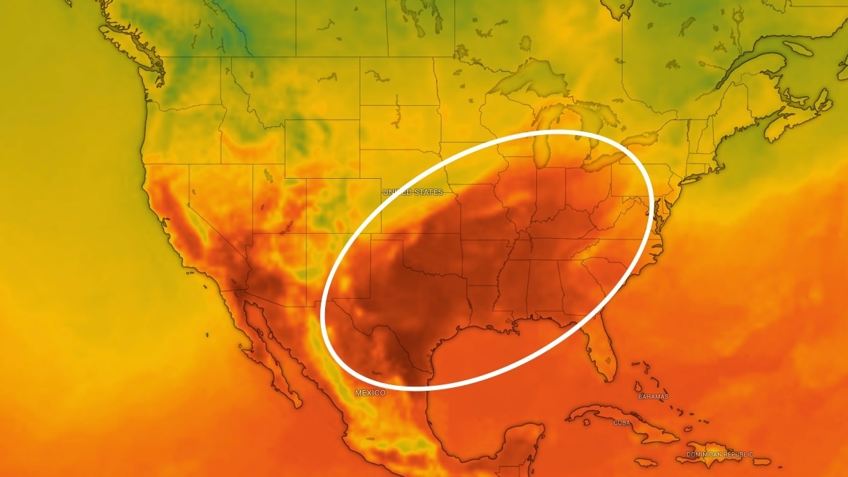
The heat dome was forecast to become the strongest high-pressure system on the planet on Wednesday, rising roughly 3.7 miles above Tennessee while channeling heat and humidity northward from the Gulf of Mexico.
3
AccuWeather meteorologist Alan Reppert attributed the ridge’s persistence partly to Pacific ocean-temperature teleconnections unrelated to El Niño, saying those signals have helped keep the heat dome centered over the southern United States.
4
In the ArkLaTex region, forecast rainfall through the following week was generally below one-quarter inch, while overnight lows were expected to remain in the lower 70s even after daytime temperatures eased into the low to middle 90s.
A massive heat dome is baking the south-central United States with dangerous late-season temperatures well above normal. NASA Science reports that across Texas, Oklahoma, Arkansas, Kansas, Louisiana and neighboring states, highs are running 5 to 10 degrees above average, with many cities breaking records. A powerful high-pressure system is suppressing clouds and rain while pulling hot, humid air north from the Gulf of Mexico, creating what The Epoch Times describes as the strongest heat dome currently on Earth.
Dallas has recorded 49 triple-digit days this year — nearly double its 20-year average of 25 — including temperatures of at least 100 degrees on 22 of the last 23 days. Austin has hit 43 such days versus a normal 29, while El Paso has recorded 52 versus 34. Heat advisories are in effect across parts of Texas, Oklahoma and Tennessee, with little relief expected through much of September.
The Strongest Ridge on the Planet
The heat dome was forecast to become the strongest high-pressure system on Earth by Wednesday, rising roughly 3.7 miles above Tennessee. This towering ridge of warm air is channeling heat and humidity northward from the Gulf of Mexico with relentless intensity. The Epoch Times quoted AlertMedia's Director of Meteorology Jason Moreland, who confirmed the heat dome stretches across tens of millions of people in the region.
Record-Breaking Triple-Digit Days Across Major Cities
Major cities across the South have shattered normal patterns for extreme heat. us.headtopics reports Dallas has nearly doubled its 20-year average of 100-degree days, hitting 49 this year. Austin has recorded 43 such days versus an average of 29. El Paso has logged 52 triple-digit days compared to a historical average of 34. These numbers show how far the current heat dome has pushed beyond typical late-summer patterns.
Mysterious Ocean Signals Keep Heat Dome Locked in Place
AccuWeather meteorologist Alan Reppert points to an unexpected culprit: Pacific ocean-temperature patterns unrelated to El Niño. These distant signals are helping keep the heat dome anchored over the southern United States. The ridge's persistence has frustrated forecasters hoping for a natural weakening. us.headtopics noted that even when temperatures ease slightly, overnight lows in the ArkLaTex region will stay in the lower 70s, offering little nighttime relief.
Dangerous Heat and Drought Through Late September
Highs near or above 100 degrees are expected through midweek and potentially into the weekend across much of Texas and Oklahoma. The ArkLaTex region will see upper-90s temperatures with warm nights and virtually no rain. Forecast rainfall for the following week is generally below one-quarter inch. Climate Prediction Center data shows the entire lower 48 United States is trending warmer than normal through September 29, with almost all areas experiencing above-average high temperatures. Forecasters do not expect substantial regional cooldown through much of September.
Sentiment
Mostly PositiveNEGATIVENEUTRALPOSITIVE
Publishers
14
Articles
44
Reach
58
A
AnonymousAuthor


